1. What is the name of the quadrangle? Beverly Hills Quadrangle
2. What are the names of the adjacent quadrangles? Canoga Park, Van Nuys, Burbank, Topanga, Venice, Inglewood
3. When was the quadrangle first created? 1927
4. What datum was used to create your map? National Geodetic Vertical Datum of 1929
NOS/NOAA chart 18744, North American Datum of 1927 (NAD 27), NAD 83,
5. What is the scale of the map? 1:24 000
6. At the above scale, answer the following:
a) 5 centimeters on the map is equivalent to how many meters on the ground? 120 meters
b) 5 inches on the map is equivalent to how many miles on the ground? 1.89 miles
c) one mile on the ground is equivalent to how many inches on the map? 2.645 inches
d) three kilometers on the ground is equivalent to how many centimeters on the map? 12.5 cm
7. What is the contour interval on your map? 20 feet
8. What are the approximate geographic coordinates in both degrees/minutes/seconds and decimal degrees of:
a) the Public Affairs Building; 34 º4’28.8”N and 118º26’21.24”W / 34 º0.0746’ and 118º0.439’
b) the tip of Santa Monica pier; 34 º00’54.8”N and 118 º30’3.6” / 34 º 0.09133’ and 34 º0.5006’
c) the Upper Franklin Canyon Reservoir; 34 º0.0967’ 118 º0.412’
9. What is the approximate elevation in both feet and meters of:
a) Greystone Mansion (in Greystone Park); 600 m / 1968.5 ft.
b) Woodlawn Cemetery; 40 m / 131.2 ft.
c) Crestwood Hills Park; 500 m / 1640 ft.
10. What is the UTM zone of the map? Zone 11
11. What are the UTM coordinates for the lower left corner of your map? 3763 362
12. How many square meters are contained within each cell (square) of the UTM gridlines? 1000 m2
13. Obtain elevation measurements, from west to east along the UTM northing 3771000, where the eastings of the UTM grid intersect the northing. Create an elevation profile using these measurements in Excel (hint: create a line chart). Figure out how to label the elevation values to the two measurements on campus. Insert your elevation profile as a graphic in your blog.
14. What is the magnetic declination of the map? 14 º East
15. In which direction does water flow in the intermittent stream between the 405 freeway and Stone Canyon Reservoir? South
16. Crop out (i.e., cut and paste) UCLA from the map and include it as a graphic on your blog.
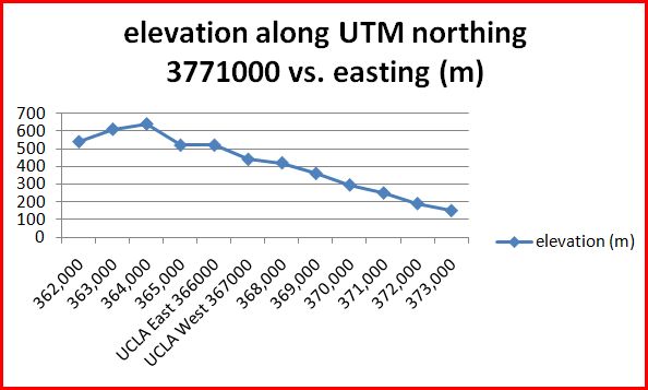


| POINTS (UTM) | elevation (m) |
| 362,000 | 540 |
| 363,000 | 610 |
| 364,000 | 640 |
| 365,000 | 520 |
| UCLA East 366000 | 520 |
| UCLA West 367000 | 440 |
| 368,000 | 420 |
| 369,000 | 360 |
| 370,000 | 295 |
| 371,000 | 250 |
| 372,000 | 190 |
| 373,000 | 150
|

grade 8.5/10
ReplyDelete8. decimal degrees are just degrees and a decimal number NOT expressed in minutes too. Also always needs N,S,E,W label or a negative sign (-) if in decimal digits and expressing W or S.
9. you're mixing up your meters and feet.
a) Greystone Mansion - 581ft. = 177m.
b) Woodlawn Cemetary - 141ft. = 43m.
c) Crestwood Hills Park - 634ft. = 193m.
11. 3,763,000mN and 361,500mE.
12. 1,000,000m²